Posts

People and places

Image
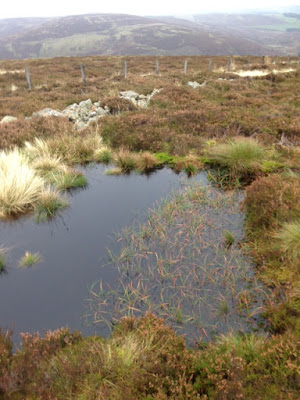
People and places Ashiestiel Hill – 4 th November 2017   Within thirty minutes we had reached the high point of the walk. Ashiestiel hill sits back from the A72, on ground above the long closed Peel hospital, a WW2 army hospital, converted to civilian use after the war before final closure in 1988. At twelve hundred feet the hill   provides a remarkable prospect over the Border terrain . Remarkable also, is the scarcity of farm dwellings or human habitation. A few large houses are tucked into the folds of the hill on the ground above the main road but nothing else takes the eye. The rough ground we have covered to reach this point is fit only for grazing, sheep and cattle scavenge among the heather and reeds to feed on hidden patches of grass and sedge. Most hills have some covering of conifers, either encasing or bisecting the hillside or appearing in ordered blocks of deep green on the flanks of the valleys. Fields, won back from the wildness of the plac...
A beguiling gloom

Image
‘A beguiling gloom’ 14 th October 2017 By mid-October the shooting season is well underway, attracting a large number of visitors to the area to partake in the dubious pleasure of blasting away at a range of feathered creatures. By accident we stumble across what we assume is a sort of open air game bird factory on our weekly perambulations around the Border countryside. Another overcast and gloomy morning but with a forecast of thinning cloud and some sunshine by lunchtime. Destination today is Seathope Law, sitting back from the A72, at a height of 542 metres; it sits close to the small hamlet of Clovernfords. We park next to a collection of houses scattered within the precincts of Holylee farm. Beyond the farm yard the track passes a well-built cairn marking a ‘holy well’ and a small damned up section of water, before striking uphill and away from Perlooie   burn, gurgling its way downhill to the Tweed river in the valley below.     It is here we begin to expe...

Mark of man

The mark of man October 7th 2017 Lindean reservoir sits on the high ground between Galashiels and Selkirk, about four kilometres east of the A7. Much of the site was dug out by hand back in the 18 th century when farmers extracted the lime rich marl clay as fertiliser. Now an impressive stretch of water with the lime rich soil, unusual in Scotland, maintaining a diverse plant population. We circle its northern bank on a dull, windy Saturday morning in early October before taking a sharp turn onto a path that runs perpendicular to the loch and running alongside the towering telecommunications tower that occupies this site. Tethered to the ground by soaring steel cables, the mast itself and the building that sits beneath it are odd additions to the landscape, military in appearance but nothing more interesting than a radio and TV communications tower, put in place in 1961 to bring ITV to the South of Scotland. Odd too its existence in this age of satellites. We drop back onto ...

Up the Dam valley

Up the Dam valley 5 th August 2017 This week up and down Damhead valley running south from the Border hamlet   of Traquair, set in the heart of the Tweed valley. A day of sunshine and sudden heavy downpours, shot blasts of rain disappear quickly on a strong westerly. The returning sun bright and intense, seeding colour and light back onto forest and hillside. The rapid weather changes engaging us differently in the landscape. Sometimes huddled and protected under a leaden sky, suddenly released to a warm uplifting sun. The valley a thing onto itself, as all valleys are, protected places. McFarlane refers to them as sanctuaries that, ‘possess the allure of lost worlds or secret gardens’ * This particular one gathers a greater sense of isolation the further it pulls us from the village below. First a slow drag up , passing a demolished bothy and a strange sort of memorial garden to local horses. Their names listed on roof slates attached to the stone dykes, some recou...

Under a green canopy

Image
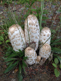
Under a green canopy 29th July 2017 The small village of Walkerburn straddles the A72 as it runs west from Galashiels before disappearing into the wilds of South Lanarkshire. A former mill town, the surrounding hills now provide new wealth from the timbers grown on them and the bike riders that make use of the tracks and pathways that run through them. On this blustery Saturday in late July we make use of these same forest roads to complete an 8 mile circular walk beginning and ending in the small car park that sits adjacent to the River Tweed. This is not a   difficult route, the most strenuous section is the long slow pull up to the height of Middleburn Knowe, a top of 414 metres. After passing through the settlement at Glenbenna we keep to the side of a small stream before a sharp turn left starts us on the upward pull. At this junction sitting proudly by the roadside and entangled by some long grasses, sits an impressive stand of Shaggy Ink mushrooms; columns of whi...

Old ways and byways

'Duchess walk' - Bowhill:- Selkirk July 15th At one time ownership of land in Scotland was distributed based on loyalty to King or Queen. From such beginnings the great sporting estates of Scotland were born. Bowhill on the   banks of the   river Yarrow, in the Scottish Borders, is one such example Gifted to the Scott clan in 1322 by Robert the Bruce for services rendered it has,   despite some upheavals over the years,   remained largely intact as a   country estate. The house and gardens are now in the ownership of the Buccleugh family, ancestors of the Scotts. On a damp sultry Saturday we park up on the edge of the estate and take the so called ‘Duchess track’ that provides a circular route of seven miles, through and around this settled realm. Heading away from the main house we quickly find ourselves alongside the tower house of Newark castle. In good condition despite it’s nearly 700 years of existence. One of many Border keeps built to ...

Up and down the River Tweed

Image
Up and down the River Tweed 8th July 2017 A warm summers day sees us walk a stretch of the River Tweed where it bisects the B6404 between St Boswells and Kelso in the Scottish Borders. At this point the river loops back and forth on itself, carving a path that creates waterside cliffs of red sandstone on one side, on the other, flat flood plains that quickly give way to fertile farmland. We park close to the riverside before crossing Mertoun Bridge to drop to the water’s edge down some timber steps. Our route keeps us close to the water throughout, running three miles east before re-crossing the river on the foot bridge adjacent to Mertoun house before returning on the far bank.   The outward stretch sees the track rise and fall through the dips and hollows of the high ground that lines this side of the river. Wooden steps and walkways allow for easy navigation, the high sections through woodland opening at times to expose slices of the river, glistening and bright in the m...