Blossoms and storm clouds
Blossoms and storm clouds
The
last few days have seen a high pressure system move across the UK from the near
continent producing a hot and humid end of May. The week itself dominated by
the Manchester bombing, the inexplicable having to be lived with, as always we
carry on. The high pressure now gets pushed back and Atlantic fronts reassert
themselves but not before a dramatic period of thunderous weather has its say.
This is promised from mid-day so we set out prepared to encounter a deluge at
some point. The objective this week is Neidpath hill, sitting between
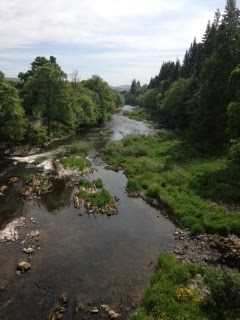
Galashiels and Yair forest to the south. The route starts from Glenkinnon
forest car park, runs back along the River Tweed to Yair bridge, joins the
Southern Upland way as it heads west, loops steeply uphill to the top of
Neidpath hill before completing the circuit by a return path to the opposite
bank of the river and a short march through farmland to the stone bridge
arching the river, close to the starting car park. A high heat dominates the
day with the promised storm clouds gradually building out east, producing scuds
of rainfall on distance hills. We luckily avoid any inundation catching only a
wee haitch of moisture shortly after we reach the top. Throughout the walk we
are assailed with the scent of early summer blossom. On leaving the car park a
group of fragrant laburnum trees, yellow catskins type flowers dropping from branches,
line the path. Close by a large rhododendron produces fists of purple flowers.
As we walk the river bank a field of daisy and buttercups carpet a large field,
on higher ground spectacular displays of white hawthorn dot the hillside.
Everywhere large tracts of dense and thorny furze – in the distance the Eildon
hills are collared by the yellow scrub. On the return path we duck beneath the
over-hanging broom as further up the valley we hear a cuckoo call. High on the
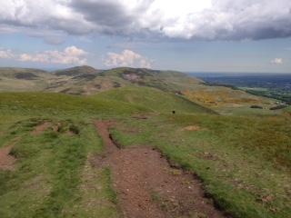
ridge line a herd of cattle are siluetted against a grey blue sky. The early and late sections of the walk are
along opposite bank of the Tweed. The middle section sees us pull quickly to
the top of Neidpath hill, a small top of 367 metres, with its lower neighbour
Hog hill close by. Both tops provide views across large panoramas of the central
border countryside. Across the valley we sight a recent walk above Thorinlee,
south of us, tucked in a fold in the hills, sits the town of Selkirk. The
gathering rain clouds see us eat a hasty a lunch before beginning the decent to
the water’s edge. We chase skylark and hares from their hiding places as the
steep drop takes us quickly down the terraced hillside. We meet the main road
and quickly cross to regain the river back. The water level sits low and the
river at many points’ looks easy to ford. The bankside is thick with wild
flowers, stands of Himalayan Balsam, great swathes of white Saxifrage and what
I think are Clustered Bell, purple flowers impressive among banks of green vegetation.
The track cuts back from the water side and into a field of tall grass and up
onto the old stone bridge close to the starting car park. We retrace the last
section through the scent of laburnum, the warmth and colour and fragrance of
the day staying with us until the end.

Comments
Post a Comment