Mark of man
The mark of man
October 7th 2017
Lindean reservoir sits on the high ground between Galashiels
and Selkirk, about four kilometres east of the A7. Much of the site was dug out
by hand back in the 18th century when farmers extracted the lime
rich marl clay as fertiliser. Now an impressive stretch of water with the lime
rich soil, unusual in Scotland, maintaining a diverse plant population. We
circle its northern bank on a dull, windy Saturday morning in early October
before taking a sharp turn onto a path that runs perpendicular to the loch and
running alongside the towering telecommunications tower that occupies this
site. Tethered to the ground by soaring steel cables, the mast itself and the building
that sits beneath it are odd additions to the landscape, military in appearance
but nothing more interesting than a radio and TV communications tower, put in
place in 1961 to bring ITV to the South of Scotland. Odd too its existence in
this age of satellites. We drop back onto a minor road before entering open
farm land. Where a ditch crosses a scoop
of land a spring breaks from the ground and runs downhill. It seeps into the
grassland creating a green swathe through an otherwise barren field. We splash
our way through and up to a sheltered path that runs for a kilometre or so to
the edge of Selkirk. A large area of water sits on the edge of the hillside,
likely a town water supply at some point given the sluice gates and earth banking
we come across. Overgrown with weeds and surrounded by pathways well used by
ramblers and dog walkers. As it happens
we meet a woman and her daughter accompanied by two dogs, both of whom have
discovered the rotting carcass of a sheep sunk into the surrounding boggy
ground. Their efforts to feed from it releasing a memorable stink. While the
owners desperately coax their dogs away, we move quickly on. The route now
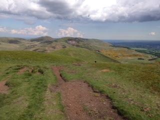
crosses the golf course and a minor road before climbing again. We clamber over
a large stile and head for the high ground in the distance. This is now common
ground , still preserved from the clutches of developers and open to all. At
the top, with great views across the surrounding valley we come across the strangest
of sights, for here sits Gala Rig, otherwise known as Selkirk race course. Atop
a high plateau and exposed to the elements, it has apparently been in place
since the 18th century and was a regular racing venue at some point.
It is now used only once a year for the local common riding. We walk the
course, impressed by how it has been engineered from the local rough heather
ground and the generally good condition it is in. By this we mean it is level,
well drained and well secured with a white plastic fencing enclosing the whole
circuit. No sign of human habitation beyond a small block building with two
doorways. One earmarked for the committee one for the jockeys. Simply adds to the
strange and melancholic feel of the whole place. Beyond we join a short section
of roadway that runs between an impressive avenue of beech trees. At one point,
on either side of the roadway a steep stone dyke raises the line of trees up before
dropping them again to the fence line a 100 metres on. This time of the year
the leaves turning quickly to brown and gold as the wind shuttles and sighs its
way through them. The last section sees us find an old drove road that meanders
up the hillside, edged by a collapsed wall and in places sunk deep into the
ground. Difficult to know its beginning and end but given its direction back
towards the reservoir may well have carried the quarried marl away from the
site all those years ago. Finally, we drop back to the water’s edge, the
surface rippled and broken by the strong breeze that accompanies us throughout.
Some spats of rain appear as we locate the car. A mixed and varied walk,
everywhere the mark of man’s efforts at improvement and progress sit within this
settled and ancient land.

Comments
Post a Comment