Yarrowford to the Three Brethern
Now in deep mid-winter the airstream has turned towards the
north and for the last week, with one brief day of remission, snow and ice and
a gurly wind have dominated our weather. Local hills are capped with white and
onto these we take ourselves during the last weekend of the year. Four miles
west of Selkirk, we cross a dog legged stone bridge to park up next to the
village hall in Yarrow ford. The whole building, road side and detached, is
painted in a garish red, at odds with its surroundings but adding colour to the
dullness of an overcast winters day A Cicerone walkers guide arrived a few days
ago so we trust to its exactitude and strike out for Walk 28, mysteriously
called ‘In search of an army’s pay
chest’. A short pull up sees us reach open ground, with good views left and
right. We stop to chat to a friends of Forbes while his girlfriend’s six year
old son has a right old shindig with a young Alsatian dog on the snowy slope
running down to the valley floor. Difficult to know who is the most feral! The
path turns sharp left and takes us on a long slow pull up to Minch moor and
onto a section of the Southern Upland Way. The surrounding hill tops are
covered in dense grey cloud the snow covered fields dissolving into the
descending gloom. The path crosses
so-called ‘Wallace’s trench’, a short but distinct trough cut into the
hillside, origins unknown but must have acted I guess as a defensive position
during some long ago conflict, but why here is anyone’s guess. We track through
a series of farm gates before reaching the open fell. My iPhone walking apps
counts out the kilometres as we trudge uphill through deepening snow. A fingerpost
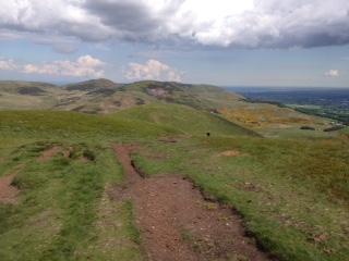
points us right towards the cairns of the Three Breathen, each marking the
estate boundary for Yair, Philiphaugh and Selkirk. Now on the exposed crest we
maintain our ascent as a flukra of snow drives in from the north. Deep wedges of snowdrift need crossing as
zips are pulled tight. We pick up the pace endeavouring to keep warm as the
temperature drops from the increasing wind chill. As the blast of snow drifts
away the cloud begins to shift from the hill tops and the route ahead appears,
a winding path hugging the hillside. The increase in light shows distinct blue
tinges in the snow as iced stands of water crush away beneath our feet. In a
small dip in the land not far from the top we hunker down in the lea of a stone
dyke for lunch. We have been on the go for three hours without stop and are in
need of sustenance. With an increasingly clear sky we reach the Three Brethren
and take in a wild stormy scene. The thick heavy cloud has receded leaving the
day blustery and wild. With the snow lying deep on the high ground the
thickness of the coverage recedes as it gets closer to the valley floor. This produces a sort of layered effect, from the
unbroken whiteness of the tops to a speckled seam below where clumps of earth , brown stands of dead bracken and spikey heather break though the
shimmering cover. Finally, before the
green fields are exposed the land is pot marked with grass and stone dykes set
off through the glimmering whiteness. The return track begins through a wooden
gate next to the columns of stone and runs parallel to a wire fence, dropping quickly
and directly to the lower ground. We identify from the guide book a paths crossroads
as our next turning point, reached about one kilometre below the top. We miss
the turning, presuming it is below us, not above. This
leads to a wide swing around the side of Foulshields hill instead of the higher
planned route across the saddle that sits on the other side of the knoll. Rounding
the hill the Yarrow valley opens before us with views across to Bowhill estate,
where we have walked a few times this year. We now navigate the side of the
valley through a series of fields, avoiding a large herd of cattle, scattering
a flock of sheep while negotiating by the site of Newark castle in the distance
and the main road that runs alongside it. We come across a stone memorial to
Tibbie Tamson, set high in the hillside within a small walled woodland. The little
ditty on the accompanying plague referencing the crack that runs
through the stone. Tibbie died sometime in the 18th century in Selkirk and for some unknown reason was buried here outside the town boundaries. Reasons for her internment at this remote spot include suicide, that she was a victim of plague, that she was insane and finally that she was a witch. Whatever the cause, she was clearly cast out by her peers and now occupies this quite spot, perhaps better thought of in death than she was when alive. The going becomes difficult as the sloping
field is slush covered and footing is easily lost. We descend to the roadside
and walk the last three kilometres back to the car on the main road, passing a
wall plate set into the wall of a ruined cottage. Inscribed on it a few details
of the life of the local explorer Mungo Park, who died in Africa at a young
age. We circle a small pond in the middle of Yarrowford village and are guided
to the car by the showy and lurid crimson village hall. Turns out the walk
derives its name from a tale of lost treasure hidden on the hillside by retreating troops after the battle of Philiphaugh in 1645. Apparently hidden in Hangingshaw wood, the reported hoard has never been found despite many attempts across the intervening years. The Yarrow valley has been full of surprises on this long, demanding, and snowy end of year trek.
 |
Snow beneath a breaking sky (Forbes Shepherd)
|
Comments
Post a Comment